The agricultural monitoring market has broken through! Jiangsu Three&three launches all-weather unmanned aerial vehicle airport unmanned operation platform

source:Jiangsu Three& three
Release time:2025-05-13
The scale of China's agricultural remote sensing market has exceeded 80 billion yuan, but traditional monitoring methods have many problems: the resolution of satellite remote sensing is insufficient, the cost of a single inspection by manned aerial vehicles exceeds 10000 yuan, and consumer grade drones rely on manual labor and are unable to perform field level monitoring. The existing equipment also suffers from weather sensitivity, lagging analysis, and high idle rates. In this situation, Jiangsu Three&three has launched an unmanned aerial vehicle airport operation platform, enabling agricultural remote sensing monitoring to be "clearly visible, accurately calculated, and used frequently".
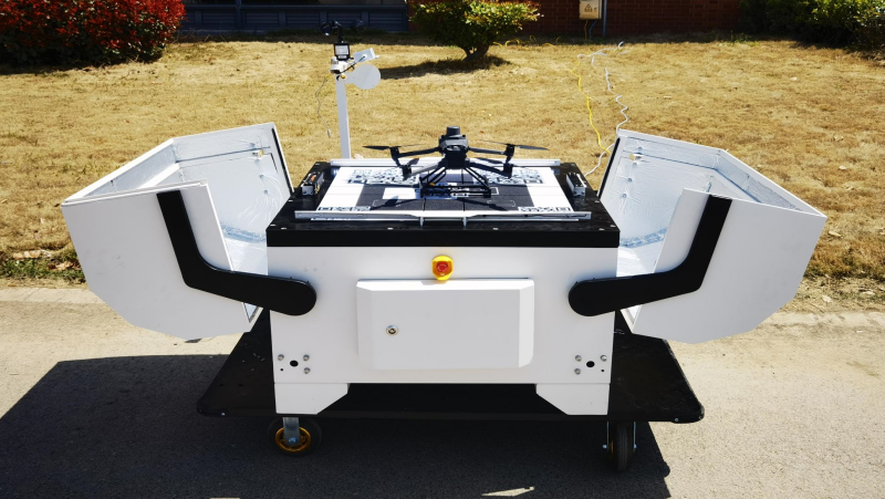
1、 Fully autonomous intelligent airport, all day escort
The entire process is automated, with one click deployment for takeoff, landing, charging, and data transmission. It has an intelligent station with multispectral unmanned aerial vehicles for fully automatic operations, with a daily average surveying and mapping area of 4000 acres per machine; Strong adaptability to the environment, built-in weather sensing module, intelligent avoidance of severe weather, with an annual effective working days of over 300 days; Ultra long endurance matrix, covering 500 acres of farmland in a single 40 minute flight, in unmanned mode, can significantly reduce labor costs and equipment idle rate.
2、 Multi spectral+AI, creating a "digital CT" in the field
Based on a crop sample library of over 100000 acres, multispectral drones can transform into "aerial guardians" of farmland and start image patrols. With a 5-centimeter ultra clear resolution, it accurately captures more than 10 types of agricultural details, such as leaf nitrogen accumulation, leaf nitrogen content, leaf area index and other key data, helping management personnel make quick decisions. Compared with traditional methods, the accuracy of agricultural identification has increased by 60%, making farmland management more scientific and efficient.
3、 Smart analysis, building a digital agriculture hub
The platform supports online collaborative operation of multiple unmanned aerial vehicle devices, implementing task triggering and scheduled task planning, which is efficient and agile; Real time video stream and image data feedback during field patrols, automatically uploaded to the cloud and quickly analyzed, with one click publishing of data services; Automatically integrate visible light and shadow images, multispectral images, and multi-dimensional agricultural information collected by drones, accurately generate drone flight trajectory records and inspection reports, and carry out comprehensive modeling analysis of key crop growth indicators such as terrain undulations, crop hole distribution, plant lodging degree, seedling growth trend, and soil fertility level; Automatically generate predictive maps covering crop seedling situation, growth dynamics, accurate diagnostic prescriptions, and yield expectations, providing precise guidance for operations, seamlessly integrating with mainstream agricultural machinery, and achieving a "monitoring decision-making execution" loop.

At present, Jiangsu Three&three has deployed intelligent airport networks in 28 major grain producing counties across the country, completing precise monitoring of over 100000 acres, reducing pesticide use by about 25%, and helping cooperative farms increase their annual income by over 120 yuan/acre. In addition, its technological potential can be further extended to the field of aquaculture monitoring, providing scientific and accurate data support for aquaculture. In the future, Jiangsu Three&three will continue to deepen its cultivation, reshape the agricultural monitoring system, empower with technology, and open a new chapter in smart agriculture.

Digital Intelligence Empowers Agriculture to Help China Influence the World
JIANGSU THREE & THREE INFORMATION TECHNOLOGY CO., LTD. is a national level specialized and innovative small giant enterprise with agricultural industry digital brain, agricultural AI big model, agricultural industry model, and agricultural intelligent terminal equipment products as its core. For a long time, we have taken the industrial Internet thinking to build agriculture, rural areas and farmers. We have successfully implemented more than 580 key projects and more than 25000 customer enterprises.
Correlation dynamics
More services and support
solution
More

-
Integrated Agricultural Service Center Solution
Central kitchen solution
Integrated solution for planting and breeding
Blockchain traceability solution
Unmanned tea plantations solution
Unmanned orchard solution
Unmanned field solution
Unmanned facility solution
Unmanned livestock and poultry solution
Unmanned aquaculture solution

 Corporate

 Worldwide
 Technology empowers agriculture, enabling humans to eat better
 Contact Us

 WeChat
 Cooperation

 WeChat official account
 Submit successfully
 Commit failure